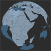
Simple Globe to put your own data with latitude/longitude
You can instanciate it like that:
var canvas = document.getElementById("3DView"); var options = { globeBackColor: "#333333FF", globeFrontColor: "#888888aa", globeLinesColor: "#000000FF" }; var globe = new Globe(canvas,options); var clickCallback = function() { console.log("cliked on image"); }; globe.addImage(48.8566667, 2.3509871, yourImage); globe.addImage(58.8566667, 2.2509871, yourOtherImage, {}, clickCallback );