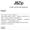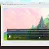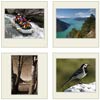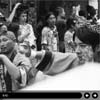
photomap.js: Photo Map
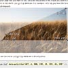
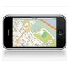
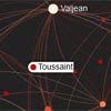
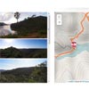
Plots the GPS data of the photos in a slideshow on a map.
Try the demo.
How to include the script
The stylesheet is best included in the header of the document.
<link rel="stylesheet" href="css/photomap.css"/>This include can be added to the header or placed inline before the script is invoked.
<script src="lib/requests.js"></script> <script src="lib/togeojson.js"></script> <script src="lib/leaflet-src.js"></script> <script src="data/exif-data.js"></script> <script src="data/gpx-data.js"></script> <script src="js/photomap.js"></script>Or use Require.js.
requirejs([ "js/photomap.js", "lib/requests.js", "lib/leaflet-src.js", "lib/togeojson.js", "data/exif-data.js", "data/gpx-data.js" ], function(Photomap, requests, Leaflet, toGeoJSON, ExifData, GpxData) { ... });Or import into an MVC framework.
var Leaflet = require('lib/leaflet-src.js'); var requests = require('lib/requests.js'); var toGeoJSON = require('lib/togeojson.js'); var ExifData = require('data/exif-data.js'); var GpxData = require('data/gpx-data.js'); var Photomap = require('js/photomap.js');How to start the script
var photomap = new Photomap({ 'element' : document.getElementById('id'), 'duration' : document.getElementById('duration'), //'tiles' : 'http://{s}.tile.osm.org/{z}/{x}/{y}.png', //'tiles' : 'http://{s}.tile.opencyclemap.org/cycle/{z}/{x}/{y}.png', //'tiles' : 'http://{s}.tile.thunderforest.com/outdoors/{z}/{x}/{y}.png', //'tiles' : 'http://4umaps.eu/{z}/{x}/{y}.png'; 'onlineTiles' : 'http://4umaps.eu/{z}/{x}/{y}.png', 'offlineTiles' : './tiles/{z}/{x}/{y}.png', 'gpx' : './xml/cowan-taffyslookout-brooklyn.xml', 'gpxData' : GpxData['cowan-taffyslookout-brooklyn'], 'exif' : 'php/imageexif.php?src=../{src}', 'exifData' : ExifData['cowan-taffyslookout-brooklyn'], 'pointer' : './img/marker-location.png', 'missing' : './img/missing.png', 'credit' : 'Maps © <a href="http://www.4umaps.eu/mountain-bike-hiking-bicycle-outdoor-topographic-map.htm" target="_blank">4UMaps</a>, Data © <a href="http://www.openstreetmap.org/copyright" target="_blank">OpenStreetMap</a> and contributors, CC BY-SA', 'zoom' : 13, 'minZoom' : 10, 'maxZoom' : 15, 'markers' : { 'start' : { 'icon' : './img/marker-train.png', 'description' : 'Transport to this location: <a href="http://131500.com.au">131500.com.au</a>' }, 'end' : { 'icon' : './img/marker-train.png', 'description' : 'Transport from this location: <a href="http://131500.com.au">131500.com.au</a>' } }, 'indicator' : { 'icon' : './img/marker-photo.png', 'description' : 'Photo taken at this location.' } });id : {string} - The ID attribute of an element somewhere in the document.
duration : {DOM node} - The duration of the GPX log will be written to this HTML element.
onlineTiles : {URL} - The source of the map tiles when an internet connection is available.
offlineTiles : {path} - The source of the map tiles when no internet connection is available.
gpx : {path} - Path to a GPS log in GPX format.
gpxData : {json} - An optional cache of GPS data in the GeoJSON format.
exif : {URL} - Path to the web service used to read EXIF information from photos.
exifData : {json} - An optional cache of geolocation data taken from the EXIF information of the photos.
pointer : {image} - An image to use for indicating the current location.
missing : {image} - An image to substitute for unavailable map tiles.
credit : {string} - Copyright information for the map source.
zoom : {integer} - Starting zoom level of the map.
minZoom : {integer} - Lowest level of zoom for which tiles are available.
maxZoom : {integer} - Highest level of zoom for which tiles are available.
start : {integer} - The starting marker of of the GPS log.
icon : {string} - Path to an icon graphic for the indicator.
description : {string} - A description to pop up in a message balloon.
end : {integer} - The ending marker of of the GPS log.
indicator : {integer} - The marker used for indicating locations.
How to control the script
Indicate
photomap.indicate(element);Highlights and centres a specific location.
element : {DOM node} - Reference to a link or image for which EXIF geolocation data is available.
Unindicate
photomap.unindicate(element);Reset the map after "indicate" was used.
How to build the script
This project uses leaflet.js from http://leafletjs.com/
This project uses node.js from http://nodejs.org/
This project uses gulp.js from http://gulpjs.com/
The following commands are available for development:
npm install- Installs the prerequisites.gulp import- Re-imports libraries from supporting projects to./src/libs/if available under the same folder tree.gulp dev- Builds the project for development purposes.gulp dist- Builds the project for deployment purposes.gulp watch- Continuously recompiles updated files during development sessions.gulp serve- Serves the project on a temporary web server at http://localhost:8500/.gulp php- Serves the project on a temporary php server at http://localhost:8500/.node node_scripts/importexif.js- Imports EXIF data and creates a JSON cache file.node node_scripts/importgpx.js- Imports GPS data and creates a JSON cache file.
License
This work is licensed under a Creative Commons Attribution 3.0 Unported License. The latest version of this and other scripts by the same author can be found at http://www.woollymittens.nl/